Study Description
Study Description
This project is a continuation of the Spring Creek Siting Study, a sub-task of the San Jacinto Regional Watershed Master Drainage Plan project (SJMDP) which was led by Harris County Flood Control District (HCFCD) with San Jacinto River Authority (SJRA), Montgomery County, and the City of Houston as partners. The Spring Creek Siting Study explored multiple alternative projects and detention siting locations to provide flood mitigation benefits to the Spring Creek watershed.
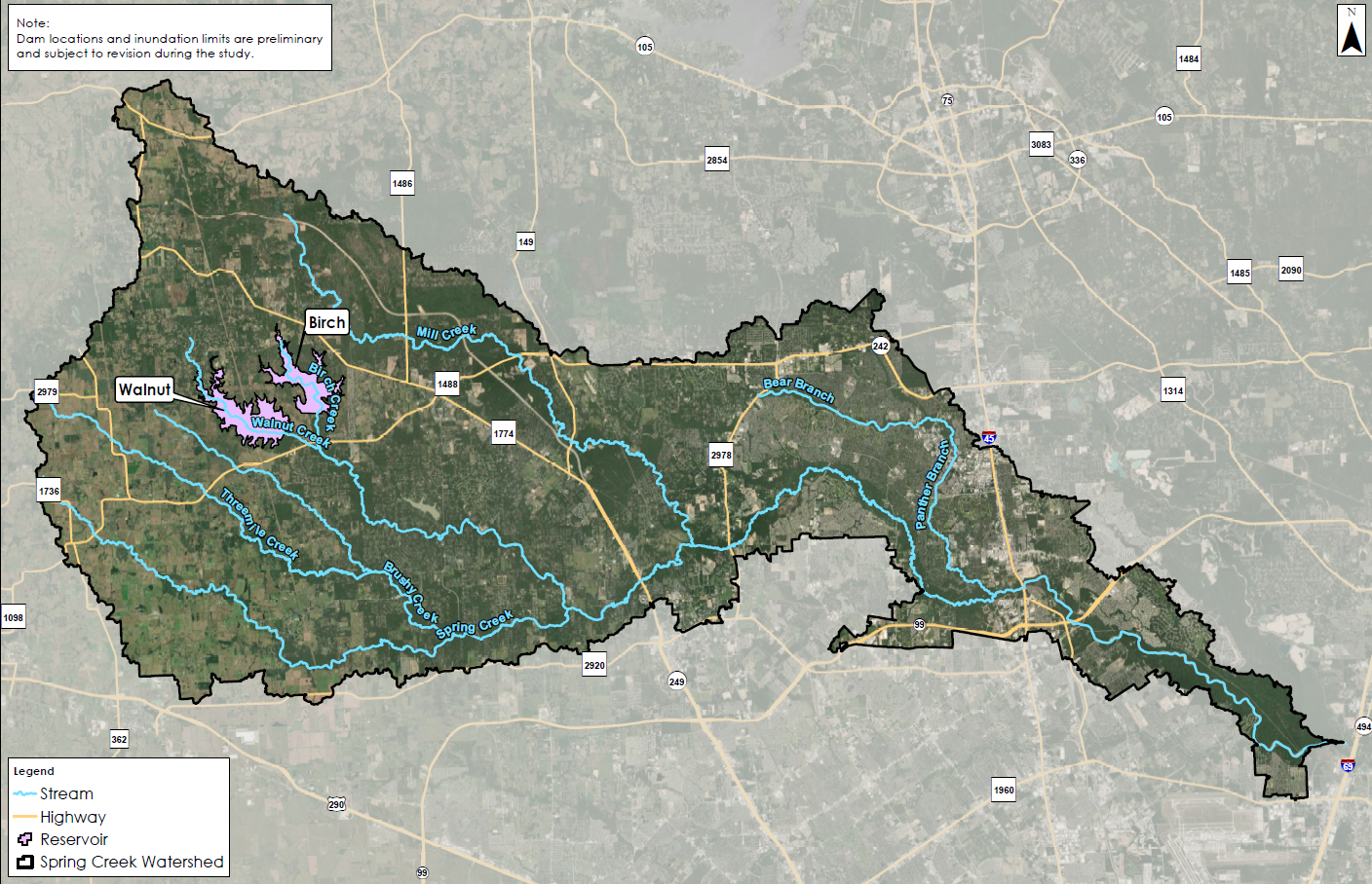
Two of the more cost-effective alternatives identified are dams on Walnut Creek and Birch Creek, which were recommended for implementation in the SJMDP. This project is planned to include a conceptual-level design for each of the two dams, as well as definition of benefits and costs for each dam and a combination of the two dams.
The outcome of this study will allow project sponsors to determine the most feasible and economical alternative(s) for design and construction. The cost of the project is estimated at up to $1 million. Fifty percent of the cost (up to $500,000) will be provided by grant funds from the Texas Water Development Board Flood Infrastructure Fund (FIF) grant program. City of Humble, HCFCD, and five (5) Municipal Utility Districts (the Partners) have together agreed to fund the remaining fifty percent local match (up to $500,000). SJRA is providing in-kind services to reduce the local match amount to be funded by the Partners.
The five Municipal Utility Districts (MUDs) supporting the Spring Creek Study include The Woodlands MUD No. 1, Montgomery County MUD Nos. 7, 46, and 60, and Harris-Montgomery Counties MUD No. 386. More information about the Spring Creek Study, including the Study Schedule, is located on the About the Study page.
Study Purpose and Goal
The purpose of the Spring Creek Study is to identify cost-effective and impactful flood mitigation alternatives by determining the feasibility of two previously sited flood control dams to reduce flooding within the Spring Creek watershed.
As Spring Creek is one of the larger watersheds in the San Jacinto River Basin (approximately 392 square miles, including over 70 miles of open streams), the extent of flood mitigation impacts will vary along the length of the creeks and within the watershed itself.
Study Area
The focus of the study is on the Spring Creek watershed, located along the border between Montgomery and Harris Counties. Project benefits are primarily upstream of I-45 on Spring Creek, with potential smaller benefits further downstream. Included below is a map of the Spring Creek watershed.

Spring Creek Study Map
Information to be Developed
The Spring Creek Study is utilizing and refining existing hydraulic models from the HCFCD to include Walnut Creek and Birch Creek. Additionally, the study team will perform environmental due diligence on proposed sites to minimize impacts and determine any potential environmental mitigation/permitting needs.
Through the Spring Creek Study, the study team is determining property acquisition requirements for the proposed flood control facilities, determining alternative layouts, and developing cost-benefit data. The information from the feasibility study will be used to identify potential funding partners and sources for future project phases.
What is H&H Modeling?
Hydrologic and Hydraulic (H&H) Modeling is a method used to determine how flood water moves over land which is crucial to developing effective flood hazard management and mitigation strategies.
Hydrology is the science of water and how water makes its way through the water cycle. There are four general components of the water cycle. These components include evaporation, condensation, precipitation, and runoff. This water cycle is studied by engineers over an area of landscape called a watershed.
Hydraulics is defined as the study of the mechanical properties of fluid movement, like water flowing in a stream. This is important because runoff from the water cycle is affected by the surfaces over which it flows. As an example, the ground surface affects the speed, direction, and depth of water as water flows back to rivers and streams. Human alterations of the earth’s surface cause water to behave differently than it would over a natural surface, sometimes speeding up the flow or slowing it down, or altering the direction and depth of the flow.
Using H&H data from the United States Geological Survey (USGS), the Federal Emergency Management Agency (FEMA), and local agencies or organizations like the Harris County Flood Control District, engineers can use an integrated system of software to simulate real-world conditions in our region’s bayous, streams, and channels. These simulations are known as H&H models. These models predict how precipitation will impact the landscape with estimates of how deep the water will get at different locations and how frequently this water depth will occur under certain weather conditions.
Study Schedule
The scope and schedule of future project phases will be determined based on the results of the study and funding availability. Construction of one or both of the dams, if determined to be feasible, would likely not occur for several years due to the need to identify a project sponsor and funding, and to perform design, environmental permitting, and land acquisition.

